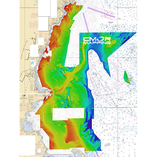


West Gulf of Mexico for Simrad, Lowrance, B & G & Mercury
The West Gulf Of Mexico CMOR Card includes coverage offshore of western Louisiana and Texas: If your looking to deep drop for grouper, tilefish and swords or find the humps that push the bait and pelagics to the surface, this is a must have chart for your boat!
The Coverage includes but is not limited to the list below.
- Deep water coverage from approximately 250ft- 12,000ft throughout the East Gulf of Mexico
- 270 sq mile nearshore Area offshore of Laguna Madre
- The Texas"HillTops"
- East Break and Little Drop
- West Flower Garden Banks
- East Flower Garden Banks
- Shelf Banks and Domes
- Most deep water Basins, Ridges, escarpments, and Domes in the Western Gulf
CMOR Mapping bathymetry arms you with more and better data than anybody else on the water.
NOAA Chart 411 and 11006 are included in the background.
All CMOR Cards come on Micro SD cards with a standard SD adapter included.
CMOR Compatible Devices:
Lowrance
- HDS Gen1 series
- HDS Gen2 series (both keypad and touchscreen)
- HDS Gen3 series
- HDS Carbon
- Elite HDI series
- Elite CHIRP series
- Elite Ti series
Simrad
- NSS
- NSS evo2
- NSS evo3
- NSE
- NSO
- NSO evo2
- NSO evo3
- GO XSE
- GO XSR
B & G
- Zeus
- Zeus Touch
- Zeus2
- Zeus3
- Vulcan
Mercury VesselView
- 502
- 702
- 703
- 903