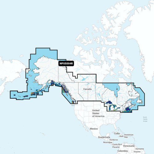

NPUS004R Canada & Alaska
Navionics Platinum+ charts include all the content of Navionics®+ cartography, with integrated offshore and inland mapping, 42,000+ lakes and additional viewing options for relief shading, satellite imagery with SonarChart shading overlay, 3D perspective view, aerial photos, and more.
Charts & Updates:
- Nautical Chart - Comprehensive charts are derived from multiple officials, government, and private sources, displayed in a familiar look and feel
- SonarChart HD Bathymetry - Innovative 1' (0.5 m) bathymetry charts are created by using Navionics proprietary systems that augment existing content with sonar data contributed by the boating community
- Community Edits - Get useful local knowledge from edits made by users of the Navionics Boating app on your compatible smart device.
- Daily Updates - Up to 5,000 daily updates to our charts give you the most accurate, most current Navionics data available.
Advanced Features:
- Dock-to-dock Route Guidance - Start your trip with a suggested path.
- SonarChart Live Mapping Feature - Watch new HD depth maps develop in real-time as your boat moves through the water.
- Advanced Map Options - Customize your view to focus on the details that matter most
- Plotter Sync - Transfer routes and markers, update chart layers, and more — between your compatible chartplotter and the Boating app.
Overlays:
- Relief Shading - Get an easy-to-interpret, clearer view of bottom structure.
- Satellite Imagery with SonarChart Shading Overlay - Experience an enhanced awareness above and below the waterline.
- Sonar Imagery - View bottom hardness clearly and in contrasting color.
Platinum+ Additional Viewing Options:
- 3D View - Adjust the perspective of your chart view to highlight key features and enhance awareness
- Aerial Photos - Get a better sense of your surroundings.
Coverage Areas:
- Worldwide map coverage is available, with integrated content making it easier to select the navigation features and map regions you want.
- Choose from large coverage areas (Large) to more localized chart cuts (Regular).
Compatibility:
- Check the compatibility of Platinum+ content and features with your GPS chartplotter.
1 Subscription is required.
2 Dock-to-dock Route Guidance is for planning purposes only and does not replace safe navigation operations.
3 Subscription not required for SonarChart Live mapping feature on some chartplotter models; requires latest chartplotter firmware release.
NOTE: Navionics+ and Platinum+ cards are not compatible with Garmin chartplotters.
**NOT FOR USE IN GARMIN CHARTPLOTTERS**


